
Trip Facts
-
- Duration
- 20 Days
-
- pax
- 2+
-
- Difficulty
- Moderate/Hard
-
- Altitude
- 5,106 m
Trip Info
Manaslu Circuit Trek is categorized as one of the best treks in Nepal and combines the high of the Himalayas and its natural beauty with rich cultural heritage and biological diversity. Manaslu Circuit Trek is now a great tea-house trek. Some call it the best all-round trek in Nepal and it’s on the Great Himalaya Trail. It’s certainly a great alternative to the Annapurna Circuit. Camping is not required unless you go off the beaten track.
Overview
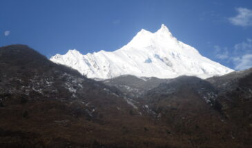
Manaslu Circuit Trekking follows a route that has long been covered by Himalayan buffs, going north behind Himalchuli (7,893 m), Peak 29 (7,835 m) and Mt. Manaslu (8,8,163m). It explores villages where westerners are still a rare sight and the way of life unchanged for decades, even centuries.
Before Manaslu Circuit Trekking would start from Gorkha (the ancestral home of the Nepalese monarchy and of the famous Nepalese Infantrymen, Now we can start trekking from Arughat because now we have road connectivity to Arughat, The Arughat bazar is in the bank of Budhigandaki River with the low and flatland then trail passes through primitive villages where the people are shy, often running away from the camera wielding trekkers. From Nyak the trails continue westward towards Namru via the Village of Ghap. There is a marked change in the culture being people and Buddhism becomes the pro-dominant religion. The trails are lined with Mani stones engraved with the eternal prayers “Om Mani Padme Hum”, meaning, “Himal to the jewel in the lotus.”
Manaslu Circuit Trekking
This is a fascinating trail with Ganesh Himal, offering a stunning backdrop with others Himalayan peaks surrounding you. On the way to Samdo, the most remote permanent settlement in these parts, you will enjoy magnificent views of Mt. Manaslu. Larke La usually snow covered, to Pangal and on to Tanbuche. After Tanbuche the trail enters a wide level valley following the expedition route to Manaslu Base camp. Crossing the Dudh Khola you will descend through rhododendron forests crossing Karche La which leads into the upper Marshyangdi River Valley. Trekking back towards Beshisahar along this valley you will again experience of the extreme demographic changes as you enter the middle and lower hills of Nepal. At Beshisahar a vehicle will be awaiting you for drive back to Kathmandu.
Why Choose Splendid High Adventure?
- Recommended by TripAdvisor
- A Leading Adventure and Travel company
- Guaranteed departure.
- Repeat Customers
- Expertly crafted packages
- Personalized packages as per your need
- Local Himalayan expert and great value
- Professional customer service
- Best Customer Service Experiences
- Responsible tour company
We esteem your valuable time and fulfillment. Hence, we try our 100% to offer the best for you and make your time here in Nepal an advantageous, fulfilling, and exceptional one!
Outline Itinerary
-
Day 1
Arrival in Kathmandu airport (1345meters).
-
Day 2
Rest day and preparation for trekking like manage the permit.
-
Day 3
Drive to Arughat (1550 meters)
-
Day 4
Trek to Soti Khola (775meters) 6 hours.
-
Day 5
Trek to Machha Khola (900meters) 5.30 hours.
-
Day 6
Trek to Jagat (1340meters) 6 hours.
-
Day 7
Trek to Ngyak (2310meters) 6 hours.
-
Day 8
Trek to Ghap (2100meters) 6 hours.
-
Day 9
Trek to Lho (3200meters) 6 hours.
-
Day 10
Trek to Sama Gaon (3500meters) 6 hours.
-
Day 11
Trek to Samdo (3850meters) 5 hours.
-
Day 12
Acclimatization and exploration day.
-
Day 13
Trek to Dharamsala/Larkya Phedi (4460meters) 4 hours.
-
Day 14
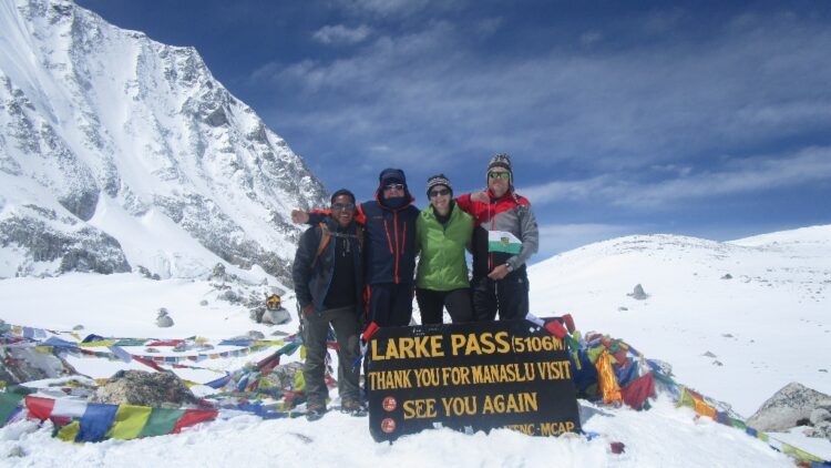
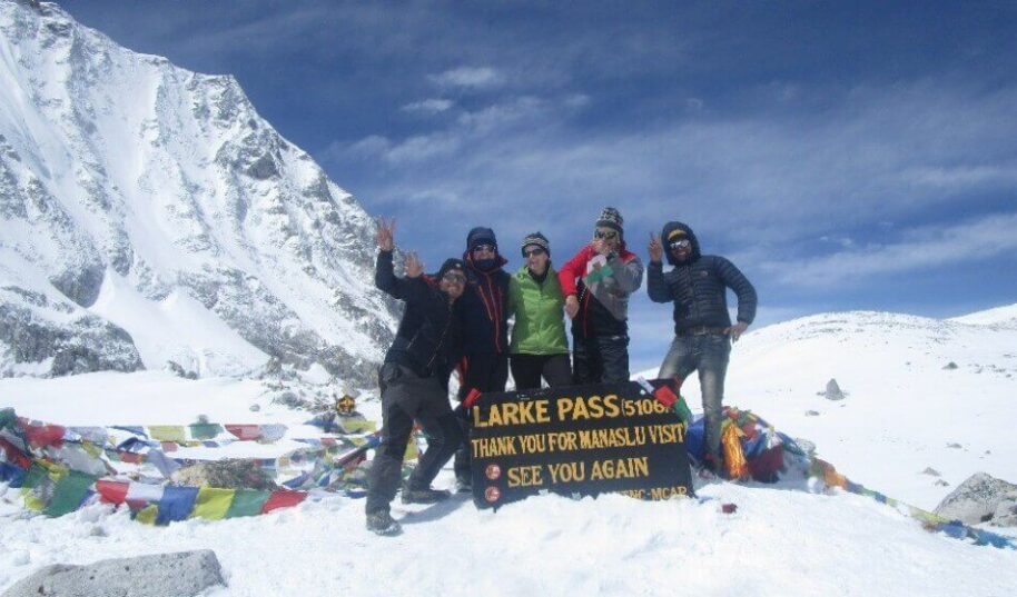
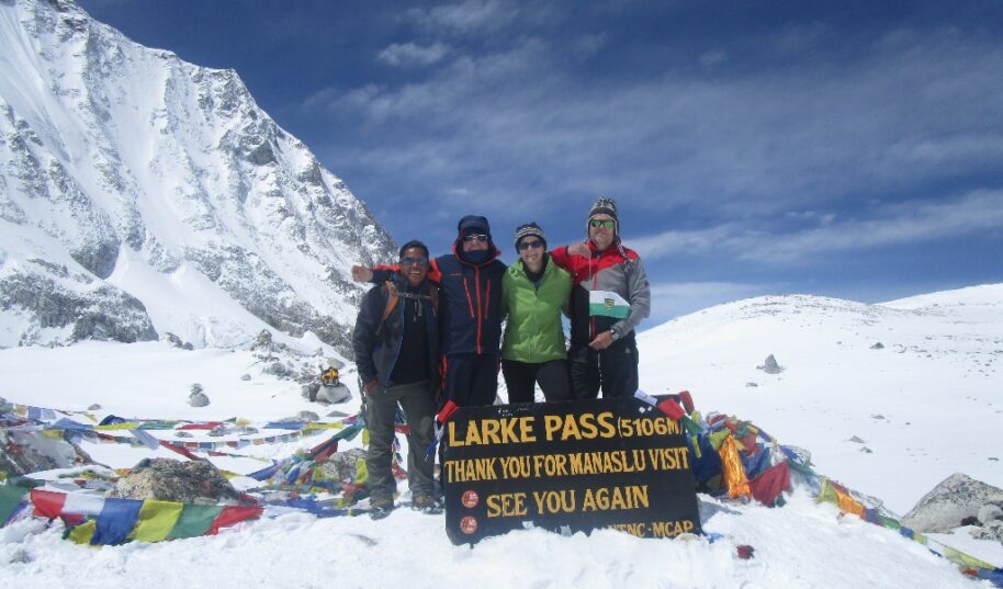
Cross Larkya La ( 5,106M) and trek to Bimtang (3590meters) 7 hours.
-
Day 15
Trek to Tilje (2500meters) 5 hours.
-
Day 16
Trek to Tal (1725meters) 5 hours.
-
Day 17
Trek to Baundanda (1275meters) 5 hours.
-
Day 18
Trek to Beshisahar. 5 hours.
-
Day 19
Drive back to Kathmandu by bus. 6 hours. At the evening farewell dinner.
-
Day 20
Transfer to international airport for your final departure.
Itinerary
When you arrive at Tribhuvan International Airport in Kathmandu, you will have to go through custom formalities. Later, you will be greeted by our representative and transferred to the hotel. When you are done with refreshment, you will visit our office where we will complete the documentation work. Enjoy the welcome dinner in the evening.
You will be picked up from the hotel and taken for the tour of UNESCO sites in Kathmandu. You will be amazed to know that there are altogether 7 UNESCO heritage sites in Kathmandu valley alone and 4 of them lies in Kathmandu city. We will start the tour from Pashupatinath, the holiest Hindu temple in Nepal. Observe Hindu crematory in Aryaghat which is located in the bank of Bagmati. Next, we will drive to Bouddhanath, the largest Buddhist Stupa in Nepal. You will rejoice to see monks in red robes chanting hymns. Later, we will continue our journey to Monkey Temple, Swoyambhunath. Believed to have been self-originated at the top of hill, Swoyambhunath dates 2500 years back and is said to be the oldest Stupa. Our next stop will be at Kathmandu Durbar Square. Taleju Temple, Stone Statue of KalBhairav, SwetBhairav, Kasthamandap and KumariGhar- the home of Living Goddess are attractions in Kathmandu Durbar Square.
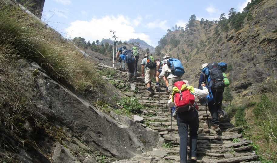
Your Trekking staff will come to your Hotel early in the morning at 7.00 am to pick you up; from there we have a 9 hour driving journey to Arughat. From Kathmandu to Gorkha Bazar for 5 hours is comfortable drive but from there to Arughat for another 4 hours we will be driving on dust road. Overnight at tea house
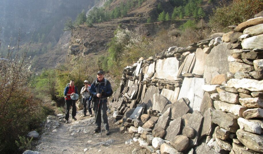
Follow the Budhi Gandaki River toward its point of origin. We pass the village of Morder and Simre to reach Arkhet River. After Arkhet we ascend slowly toward Kyoropani. Camp today nears the confluence of Seti River – an ideal place to take a fresh water bath. Overnight at tea house
The trail descends slowly until you climb again to mountain ridge to Almara. Pass the forest trail to arrive at Riden Gaon. The valley here cuts into another side of the river to enter Budhi Gandaki. At Lambesi, the trail follows down to the sandy river bed of Budhi Gandaki. Camp tonight at Machha khola, Overnight at tea house
After crossing Machha River and Khrola besi, there is a hot spring called “Tatopani”. The trail follows forested area after this toward Dovan. Below Dovan, there is a huge rapid at Budhi Gandaki. As the elevation increases, the rapids and the scenery undergoes a complete transformation. At Jagat, there is a police check-post where your trekking permit will be checked. Overnight at tea house
After ascending to a terraced hill of Saguleri and view of Sringi Himal (7177 meters) we continue toward Sirish Gaon, Gandaki valley narrows from herewith soaring precipitous walls. Overnight at tea house
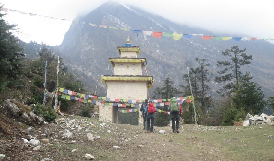
Follow the trail upstream of Deng River – a tiny village of 4 houses. We walk through a newly built rock tunnel from here, thus avoiding the traditional steep climb. At Ghap, the Tibetan culture begins with Mani stones and chortens all around. Overnight at tea house
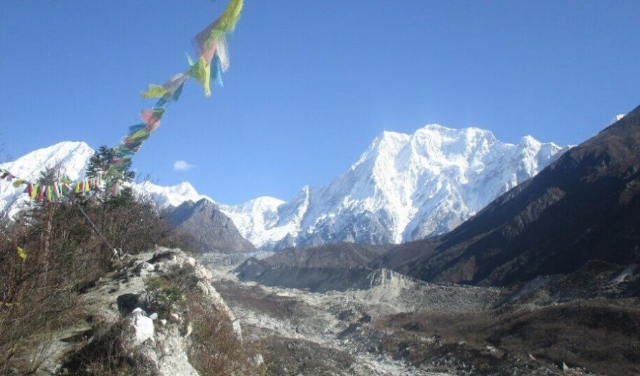
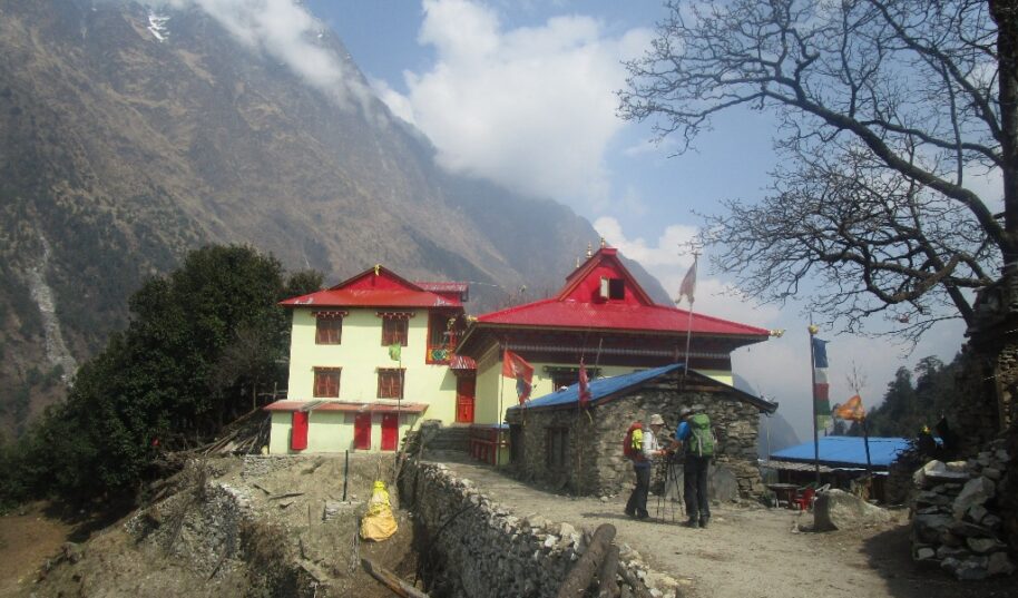
Today is a wonderful trekking day; after passing through the seemingly deserted seasonal village of Nambachhe, planted with fields of barley and lined with mani walls, we ascend through a dense, cool forest for an half an hour, crossing the Buri Gandaki once on a wooden bridge, to Namrung, at 2540 meters, where we will stop for a cup of chai at a lodge run by a Tibetan family. As we gain altitude, we reach alpine territory and are treated to increasing mountain views. Namrung village is the start of Nubri, the region of purely Tibetan inhabitants speaking a dialect of western Tibet. Above this village the valley opens out and there are extensive pastures. A few hours later, we reach the village of Lihi at 2840 meters, a substantial altitude gain. We are climbing climb gently now, cross a large stream flowing down from the Lidanda Glaciers, and reach the picturesque Tibetan village of Sho at 3000m, where we stop for lunch. Look for the bear claw on the upper deck of the house, and across the river to the ruins of an old Tibetan fort. From Sho, the views of Ngadi Chuli are spectacular, and further on, towards Lho, we are finally treated to views of Manaslu itself; quite an impressive afternoon! We set up camp in Lho, a lively village adorned with many prayer flags, in the yard of a small lodge. Sunset and sunrise from the campsite are wonderful, and the small gompa just below our campsite worth a visit. Overnight at tea house
Walking through the upper reaches of Lho, with the snowy peaks of Manaslu ahead of us in the distance, we pass the new gompa and then ascend through light forests next to a small river to reach the Tibetan settlement of Shyla, where the villagers are often out in the fields. Another few hours of trekking through classic alpine scenery leads us past Tibet grazing settlements, the train to Pung Gyan Gompa, and then Sama Gaon, or Ro, as the locals calls it. Sama Gaon sits in a bowl at the foot of the pastures leading to the high peaks, with mani walls, a small gompa and tightly packed rows of houses at the lower reaches of village, and the large gompa at the upper reaches. The people settled here from Tibet over 500 years ago, and the two gompas date from this time, both having unique architecture and built of wood. The Tibetan villages here have entrance gates which are very distinctive from the Tibetan ones, and they maintain an active trade with their co-religionists in Tibet (notice the Chinese brandy and beer on sale). If the weather is good, you will see the village women weaving wool (baal) from Tibet into gowns – which are then traded back to Tibet. Taxes were actually paid to the Dzongka Dzong (fortress) at the border of Tibet, a few days walk from Sama Gaon, as late as the 1940’s until it was taken over by the Gorkas in the late 19th century. Later, after 1959, the region was home to Tibetan guerillas, and thus closed to trekking until 1992. Take the afternoon to hike up to the gompa above town, and to wander the streets of the fascinating Sama Gaon village. Overnight at tea house
Another day of incredible mountain views during the walk up to Samdo, an easy three hours away. En route we pas the long mani walls at Kermo Kharka, after which we spot the entrance chorten of Samdo high on a bluff. We descend back to the Bhudi Gandaki and cross a small bridge before another short climb to the ‘kane’ entrance of Samdo; look back down valley for great views. The villagers of Samdo came across the border from the village of Riu after 1959 and built their new village here, at their old herding settlement (see below). Samdo village is a collection of houses and lodges at 3850 meters, and most trekkers miss the heat of a week ago as we huddle around the stove and a wind from Tibet batters the windowpanes. Get out and take a walk around the village, where the inhabitants live an essentially Tibetan lifestyle, herding their yaks, sheep and goats, training their horses and planting barley. There is a small home gompa in a house mid-village which we visited during our last village, a puja being held by several of the reincarnated lamas living in the Samdo. Overnight at tea house
We will spend a day here in order to acclimatize and adjust to the thinning of the air and also for local excursion. On our rest day here why not a day trip to the border of Tibet; no passport required. It takes five hours walking to the Gya La (‘large pass’) to do just that, and then take in the views and ruminate on the border markers at the top: ‘China, 1962.’ We will probably share the trail with groups of Samdo residents, carrying timbers over the border to Tibet. True High Asia! Like the people of Ro, Samdo inhabitants are Tibetan, and were ceded the land by the king of Jumla over 500 years ago; but, unlike the Ro people, they only claimed their land after the Chinese takeover in the early 1950s. Since then they have established a trade with China and India, marketing among other things, the aphrodisiac root that grows in the region. We’ll try to get into some of the local houses for chang (Tibetan barley beer), salt butter tea and perhaps a few carpets to buy! Overnight at tea house
We leave on the trade route to Tibet and climb through the ruins of Larkya bazaar, one of the trade markets that flourished years back. After two hours of climbing past glaciers, with increasingly awe-inspiring panoramas, we come to the campsite at Dharamsala, where we have lunch and gaze out at the views. You’ll really feel the altitude and the cold here, so enjoy a more leisurely afternoon and keep warm. We’ll have an early dinner in preparation for our pass crossing tomorrow. Overnight at tea hous
After a short climb above the campsite, we reach the ablation valley on the North side of the Larkya Glaciers where we have views of Cho Danda and then of Larkya Peak. We continue across the moraines of the glacier, making a gradual ascent which becomes steeper only in the last section to the pass, which should take us about three hours to crest. From the pass, there are outstanding views of Himlung Himal, Cheo Himal, Kangguru and the huge Annapurna II. If there is fresh snow, we may see Snow Leopard prints from the evening before; it’s also blue sheep (Bharal) and Tibetan Snow Cock territory.
The views from the top of the pass are truly unbelievable. After hanging our Tibetan prayer flags, and yelling ‘Ki ki so so lha gyalo’ (may the Gods be victorious), get ready for a steep, ankle straining drop to a trail following the glacial moraine, very slippery if covered in snow so have your ‘Yak tracks’ ready if you’ve brought them, and definitely use trekking poles. It is a longer day then usual to our campsite at Bimtang, but to walk into these low pastures with the evening mist coming in and Manaslu; it’s an experience not to be missed. A boulder-strewn descent brings us, finally, to Bimtang, Overnight at tea house
The campsite at Bimtang is frigid in the morning, so get to the dining tent quickly for a cup of fresh coffee! Porters pour hot water over tent pegs to get them out. Pee bottles freeze. No option if you want to get warm, move down valley into the sun, through forested hillsides to Tilje, at the end of our lost world. Here the inhabitants are a mix of Manangis (of Tibetan descent) and Chettris (Hindus), so eat a mix of dal bhaat, buckwheat dhido, tsampa and Tibetan tea. The gorge ahead marks the land of apple pie, cold beers and hot showers – the Annapurna Circuit. Overnight at tea house
Follow the trail downstream of Marshyangdi River, passing through the scattered villages to reach Tal village for overnight stay. Overnight at tea house
Ascending gently for 30 minutes and the trail runs gently down to Sanjee village, then trail goes up for 15 minutes to Gharmuu Phant. From here another 2 hours easy walk and 30 minutes up will take to the village of Bahundanda. Overnight at tea house
The last day of the trek, and a hot, five hour walk through gentle, muted hills and colorful villages to Bhulbhule and Khudi, where we will meet our transport back to Besi Sahar. If the road isn’t passable, we continue walk to Besi Sahar to start the five-hour drive back to Kathmandu following morning. And drive back to Kathmandu will be very joyful with terrace rice field and pass many villages, overnight at Hotel.
It is a different world back in the Nepali hills, and the gentle light sends us on our way back to the bustle of Nepal’s capital.
The trip ends, our Airport Representative will drop you to the Kathmandu international airport for your final flight departure from Nepal.
included:
- Airport pickups and drops in a private vehicle
- 3-star hotel accommodation in Kathmandu with breakfast
- Teahouse and lodge accommodation during the trek
- All meals (breakfast, lunch and dinner) during the trek
- well come dinners with Nepalese cultural dance and farewell dinner
- All ground transportation on a comfortable private vehicle as per the itinerary
- An experienced, English-speaking and government-licensed trek leader (trek guide)
- Staff costs including their salary, insurance, equipment, food and accommodation
- All necessary paperwork and trekking permits (Restricted are Permits, ACAP and MCAP)
- Trekking completion certificate
- Medical kit (carried by your trek leader)
- All government and local taxes and VAT
Doesn’t Include:
- Nepalese visa fee
- Extra night accommodation in Kathmandu because of early arrival, late departure, early return from mountain (due to any reason) than the scheduled itinerary
- Lunch and evening meals in Kathmandu
- International flights
- Travel and rescue insurance
- Personal expenses (phone calls, laundry, bar bills, battery recharge, extra porters, bottle or boiled water, etc.)
- Tips for guide(s), porter(s) and driver(s) (it is expected)
Gallery


Cost and Dates
- Small Group Journey
- Private Journey
- Customize Trip
The set departure dates listed are specially quoted and specified for group joining option. Let us know if the set departure dates are not suitable for you- another dates which are suitable for you can certainly be added by uss.
Check Available Dates
Related Trips
Manaslu Circuit Trek with Tsum Valley
Manaslu Tsum Valley Trekking is a journey around Manaslu combined with the exploration of the mystical Tsum Valley. Manaslu is a beauty beyond...