Trip Facts
-
- Duration
- 19 Days
-
- Altitude
- 6610M
-
- pax
-
- Difficulty
Trip Info
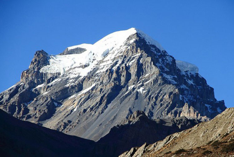
Chulu west (6610M) is the highest of the two Chulus and has a higher recorded altitude by at least two expeditions that have ascended it. This peak was first climbed in 1952 by a Japanese expedition. Ascents to this peak are best made from a base camp in a small valley north of Manang, situated at the main trail to the Thorong-La. From here one gets to see some of the best views of the peaks. There is considerable debate in regard to the name and location of the Chulu peak, for those who have climbed this area, it is a known fact that several other summit close by, which are actually part of the Chulu massive, are not indicated on maps. Therefore it is hard to distinguish between the two Chulu, however, for the sake of charity; four summits can be included in the Chulu group. Two each for west and East, Though Chulu west could also possibly be called Chulu central. Although there really is not any technical difficulty on this section, in soft snow however, progress could be slow and difficult, as the slopes are prone to “Avalanche” in certain conditions.
Overview
Chulu west (6610M) is the higher of the two Chulus and has a higher recorded altitude by at least two expeditions that have ascended it. This peak was first climbed in 1952 by a Japanese expedition. Ascents to this peak are best made from a base camp in a small valley north of Manang, situated off the mail trail to the Thorong-La. From here one gets to see some of the best views of the peaks. There is considerable debate in regard to the name and location of the Chulu peak, for those who have climbed this area, it is a known fact that several other summit close by, which are actually part of the Chulu massive, are not indicated on maps. Therefore it is hard to distinguish between the two Chulu, however, for the sake of charity; four summits can be included in the Chulu group. Two each for west and East, Though Chulu west could also possibly be called Chulu central. Although there really is not any technical difficulty on this section, in soft snow however, progress could be slow and difficult, as the slopes are prone to “Avalanche” in certain conditions.
Feature of trekking.
Area: Annapurna Region.
Culture: Mixed influences among the majority of Gurung, Magar and Thakali caste
Maximum Elevation: Chulu West (6610M)
Trekking Grade: Moderate/High Altitude
Starting Point: Beshishar
Ending Point: Pokhara
Trekking duration: 16 days
Total Duration: 19 Days
Best season: Sep, Oct, Nov- Mar, April, May
Accommodation: Tea house and camping
Transportation: By flight, private car or tourist bus.
Meals: Breakfast, lunch and dinner during the trek
Type of Trekking: Camping/Tea house both
Himalayan sights: Mt. Annapurna, Dhaulagiri, Nilgiri and Manaslu etc.
Outline Itinerary
-
Day 1
Arrival in Katmandu Transfer to hotel and in the evening well-come dinner.
-
Day 2
Drive to Ngadi beyond Beshisahar takes (7-8hours) overnight in hotel.
-
Day 3
Trek to Chamje (1410m) takes 6 hours
-
Day 4
trek to Danaque (2300m) takes 6-7 hours.
-
Day 5
Trek to Chame (26070m) it takes 5-6houras.
-
Day 6
Trek to Pisang (3200m) takes 5-6hours.
-
Day 7
Pisang to Manang village (3,450m)
-
Day 8
Acclimatization day at Manang
-
Day 9
Manang to Leather (4,200m)
-
Day 10
Leather to Base Camp (4,400m)
-
Day 11
Base camp to High Camp (4,685m)
-
Day 12
Summit day and back to camp Letder (6,419m)
-
Day 13
Reserve day for unforeseen condition
-
Day 14
Letder to high camp (4,800m)
-
Day 15
Cross Throng la (5,416m) and to Muktinath (3,800)
-
Day 16
Trek to Jomsom (2,700m)
-
Day 17
Early morning flight to Pokhara (820m)
-
Day 18
Drive from Pokhara to Kathmandu
-
Day 19
Departure from Kathmandu
Cost and Dates
- Small Group Journey
- Private Journey
- Customize Trip
The set departure dates listed are specially quoted and specified for group joining option. Let us know if the set departure dates are not suitable for you- another dates which are suitable for you can certainly be added by uss.
Check Available Dates
